This GPS Map Camera app merges camera functionality with GPS location tracking, enabling users to visually document their journeys. Key features include geotagging, GPS scanning, and GPS mapping, allowing for the creation of photo maps showcasing travel routes. The app's intuitive interface seamlessly integrates with GPS-enabled devices.
Here are six key benefits of the GPS Map Camera App:
-
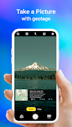
Integrated Camera and GPS: Capture photos while simultaneously recording precise geolocation data, creating a visual travelogue.
-
Versatile Photo Capture and Tracking: Use the built-in GPS camera or add GPS location data to existing photos.
-
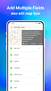
Comprehensive Mapping System: Easily view photos on a GPS map, visualizing their locations along a route.
-
Customizable Date/Time Stamps: Add date and time stamps to photos in your preferred format.
-
Customizable Photo Management: Save photos with custom names and utilize live navigation for efficient organization.
-
Lightweight Option Available: A Lite version offers many core features while minimizing device storage usage.